


Torrential in the north, dry in the south: Spain weather forecast November 10-13
A new Atlantic front will bring fresh downpours to the west and north of Spain, but the Mediterranean should remain dry
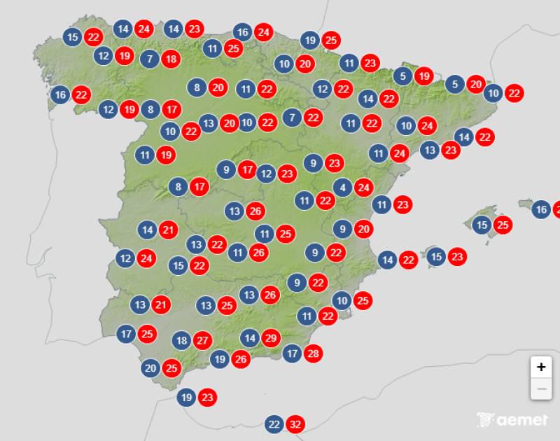
Average day-time temperatures expected on Thursday November 13
This week all eyes are trained on the Atlantic again as fronts associated with low-pressure systems will be moving towards the northwest of the country in the next few hours. Rainfall is expected to increase from midweek onwards, and once again the most affected regions will be municipalities in the north and west of Spain. Strong winds and heavy swells will also be prominent, especially in areas of the northwest, while the Mediterranean is expected to be mostly dry.
Monday November 10
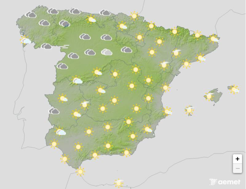
The week will begin very overcast in northern Spain and partly cloudy in the rest of the country, although the skies should clear later in the day further south. Widespread and sometimes heavy rain is expected in the north and mountainous areas of central Spain.
Daytime temperatures will show little change but Monday night should be a little milder than the weekend.
Tuesday November 11
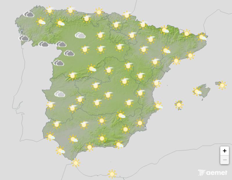
Tuesday will be marked by the Atlantic front moving in from the northwest of the Iberian Peninsula. Cloudy or overcast skies are expected along the Cantabrian and Atlantic slopes, with high cloud cover becoming more prevalent further south, as well as abundant high-level cloud cover in the rest of mainland and the Balearic Islands.
An orange warning for rainfall has been activated in Galicia, with yellow alerts elsewhere in the north.
The path of the storm is uncertain but for the moment at least, the south of Spain should avoid any rain.
Night-time temperatures will continue to climb and the day should also be a bit warmer along the eastern coast.
Wednesday November 12
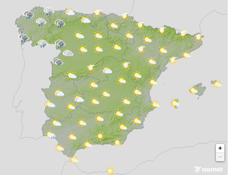
The front is expected to remain practically stationary over the northwest of the country and, throughout the afternoon, rain will also hit the western Canary Islands. The rest of Spain can expect some high cloud cover with plenty of bright spells, although there’s a chance that the rain will spread to western communities later in the day.
Maximum temperatures will decrease slightly in the far northwest and rise in the rest of the country and the Balearic Islands.
Thursday November 13
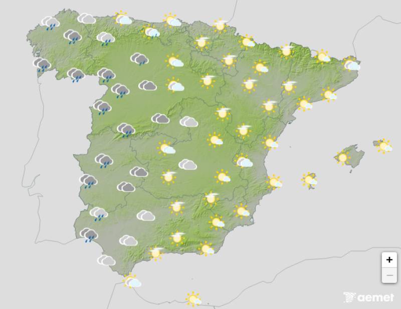
Very cloudy or overcast skies are forecast in most of the country on Thursday. The heaviest rain will fall again in western Spain, but it’s likely to spread in the form of showers. However, the State Meteorological Agency (Aemet) expects it to remain dry in the extreme southeast and the Balearic Islands.
Maximum temperatures will rise in the northern third of the country, along the Mediterranean coast and in the Balearic Islands while night-time temperatures should inch up across the board.
Join our Spain Weather Watch Facebook group for all the latest weather and climate change news
Images: Aemet


Sign up for the Spanish News Today Editors Roundup Weekly Bulletin and get an email with all the week’s news straight to your inbox
Special offer: Subscribe now for 25% off (36.95 euros for 48 Bulletins)
OR
you can sign up to our FREE weekly roundup!
Read some of our recent bulletins:
Discount Special Offer subscription:
36.95€ for 48 Editor’s Weekly News Roundup bulletins!
Please CLICK THE BUTTON to subscribe.
(List price 3 months 12 Bulletins)
Read more stories from around Spain: